Real World Height Remap Node
- Category: Adjustments
- Edition: Vista Pro (Real World Data)
- Output type: Height
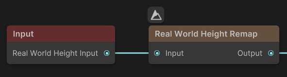
- Typical place in a graph: right after the real world height input of a Real World biome
Real World Height Remap turns downloaded elevation data back into real heights. Elevation services deliver heights squeezed into 0 to 1 over their own range (for USGS, about -58 m to 3922 m). This node spreads that data back over the real range in meters, then fits it into your terrain's height. With the right settings, a mountain that is 1200 m tall in reality is 1200 m tall in your scene.
When to use it
- Every Real World biome that uses downloaded elevation, to get correct heights in meters.
- Exaggerate or flatten real relief on purpose, by changing the range.
- Not for: general range changes (use Levels or Remap).
Inputs
| Slot | Type | Required | What to connect |
|---|---|---|---|
| Input | Mask | Yes | Downloaded elevation data, normalized from 0 to 1 by its source service. Usually the Real World Height Input from an Input node, or the height from Load Real World Data. |
Outputs
| Slot | Type | What it holds |
|---|---|---|
| Output | Mask | The elevation in meters, divided by your terrain height, so it can go straight to the Height Output. Real heights above the terrain height are cut at full height; below 0 m, at the floor. |
Properties
| Property | Default | Range | What it does |
|---|---|---|---|
| Pick from Provider | (empty) | A data provider asset | Drop a data provider asset here to fill in its lowest and highest possible heights. The field empties again afterwards; it only reads the values. |
| Dest Min Height | -58.37 | meters | The real height that input 0 stands for: the lowest value the elevation service can deliver. The default is the USGS service's minimum. |
| Dest Max Height | 3922.47 | meters | The real height that input 1 stands for: the highest value the service can deliver. The default is the USGS service's maximum. |
Common properties
| Property | What it does |
|---|---|
| Id | The node's unique name in this graph, shown for reference. You cannot edit it. Scripts and the AI workflow CLI use it to find the node. |
| Resolution | How detailed this node's result is, in texels across the biome. Relative To Main Input (default) matches the downloaded height, times the multiplier below it. Relative To Graph follows the biome's Canvas Resolution instead. Absolute sets an exact size. Absolute is limited to 32 to 4096 in Vista Pro. |
| Split Execution | Lets this node run over several frames so the editor stays responsive during long generations. It only works when Allow Split Execution is on in the graph settings. This node finishes in one step, so splitting only adds a short pause around it; leave it off. |
| Bypass | Skips the node. The normalized data passes through, so the terrain gets the service's 0 to 1 range stretched over your terrain height, with wrong heights. |
How it works
For each point: height in meters = Dest Min Height + input × (Dest Max Height − Dest Min Height), then output = height in meters ÷ terrain height. For example, with the USGS defaults and a 2000 m terrain, an input of 0.3 is about 1136 m and comes out as 0.57.
Recipes
- Real terrain at real scale: Real World Height Input → Real World Height Remap (Pick from Provider with your provider) → Height Output. See Height data remapping.
- Exaggerated relief: set Dest Max Height higher than the service's real maximum to stretch the mountains taller.
Warning
Set the Vista Manager's Max Height at least as high as the tallest real point in your area, or the peaks are cut flat.
Note
For a different data provider, use Pick from Provider so the range matches that service. A wrong range scales every height by the wrong factor.
Performance
Very cheap: one quick GPU step.
Related nodes
- Load Real World Data: download elevation and color in the graph.
- Input: reads the real world height a Real World biome provides.
- Levels, Remap: general range changes.
For AI agents
- Type name:
RealWorldHeightRemapNode(Vista Pro, Real World Data module). Input0, Output100. - Properties:
destMinHeight,destMaxHeight(meters; defaults are USGSDataProvider.MIN_HEIGHT and MAX_HEIGHT). - Output = inverseLerp(0, terrainHeight, lerp(destMin, destMax, input)).